

35 Best Short Walks in the North Island (Top NZ Hikes)
Last updated on August 2nd, 2026 at 04:31 am
Disclaimer: This post contains affiliate links. If you make a purchase through them, I may earn a small commission at no extra cost to you.
If you want to experience New Zealand’s dramatic landscapes without spending days carrying a heavy backpack you are in the right place. The North Island is packed with incredible scenery, and you don’t need to be an avid hiker to see some of the best the island has to offer!
These 35 short walks or short hikes will give you everything from beautiful turquoise springs and volcanic landscapes, to coastal rock arches, waterfalls, and bubbling geothermal wonders. The often overlooked North Island does have some of the most accessible scenery there is, and these short walks pack a massive punch. Even better – it really wont take too much effort at all. Yah!!
So whether you are a casual stroller, short on time, bringing your kids or grandma, this list is made for you. Every single track on this list takes under two hours, so grab your camera and put on your runners – and lets go exploring the North Island!
Contents
The 35 best short walks in the North Island!
Things to pack when hiking in New Zealand
Frequently Asked Questions about walking and hiking in New Zealand
Trip Planning Checklist
These are the booking platforms I personally use for all my travels. If you book through these affiliate links, it helps support this site and keeps me producing free travel guides – at absolutely no extra cost to you. Thanks so much for the support! Cheers!
All in one – if you want to book flights and accommodation as a package, use expedia
Flights – use skyscanner or booking.com to find and book your flight – I often find the same flight cheaper than booking direct with the airline!
Accommodation – I use booking.com for hotels, Hostelworld for a hostel, and Vrbo for holiday houses.
Internet – buy a yesim eSim or Airalo before you go. I use both depending on where I am going.
Tours and Activities – book with Viator or GetYourGuide, and in NZ always check Bookme as it has good discounts on many attractions. Top picks for walks are:
- 1. Private Piha Beach, Rainforest Adventure & Mt. Eden with Guide
- 2. Take a cruise from Whitiangi to Cathedral Cove – it makes the walk very easy!
- 3. Rotorua Hiking: Mt Tarawera Guided Volcanic Crater Experience (although its a little longer than 2 hours!)
Car rental – I usually use DiscoverCars
Insurance – I usually use EKTA , but another good option, especially if you are from the US is SafetyWing. EKTA works well as they accept any nationality, any age and its ok if you are already traveling – which is perfect for me!
Buses, trains, ferries – 12Go is often my first option for buses, ferries and trains – they are expanding worldwide but are very strong in Asia. They cover parts of Europe like Germany and France, and Australia and Latin America – especially Argentina.
Hiking – I use AllTrails for online and offline hiking trails – it means you know exactly where you are on the trail and makes getting lost a lot harder!!
Thanks so much if you used one of these links – it costs you nothing but helps me keep writing!
The 35 best short walks in the North Island
These walks or short hikes are given in rough north to south order – not in order of preference.
Note that walking times given are for average walkers – not too slow, and not too fit and fast.
So here we go with the best short walks in the North Island – listed in order from north to south.
1. Cape Reinga Lighthouse Walk
Time and distance: 20 mins, 1.5km return
AllTrails Map: Cape Reinga from Cape Reinga Road End
Start at the carpark at the very top of the North Island – it’s the end of the road. Take the extremely obvious path from the carpark to the lighthouse.
The views are constant and when you reach the lighthouse take time to watch the Pacific Ocean collide with the Tasman Sea. This is a significant place for Māori, as it is seen as the place your spirit leaves the land when you pass from this life.
Stay in the far north at..
Mid Range – Mukies Apartments, or, Mangonui Waterfront Apartments
Budget – Mid Range – The Perch Northland, or, Private Olive Grove Studio
Budget – Kiwi Call Cottage or Gumdiggers Tiny House

2. St Paul’s Rock Track
Time and distance: 1 hour, 1.5km return
AllTrails Map: St. Paul’s Rock Track
Start at the carpark at the end of the Old Hospital Road in the small Whangaroa township.
Take a short steep climb through manuka bush to ‘the rock’ where you get drop-dead views across the Whangaroa Harbour. Much easier than its counterpart on the other side of the Harbour – the Dukes Nose! (Read about that hike in the 12 great multi-day hikes in the North Island New Zealand (off the beaten path))
Stay in the far north at..
Any of the places mentioned in walk 1 above.
3. KeriKeri River Track
Time and distance: 1.5 hours, 3.5km one way
AllTrails Map: KeriKeri River Track
Start at the carpark at the end of Landing Road in KeriKeri.
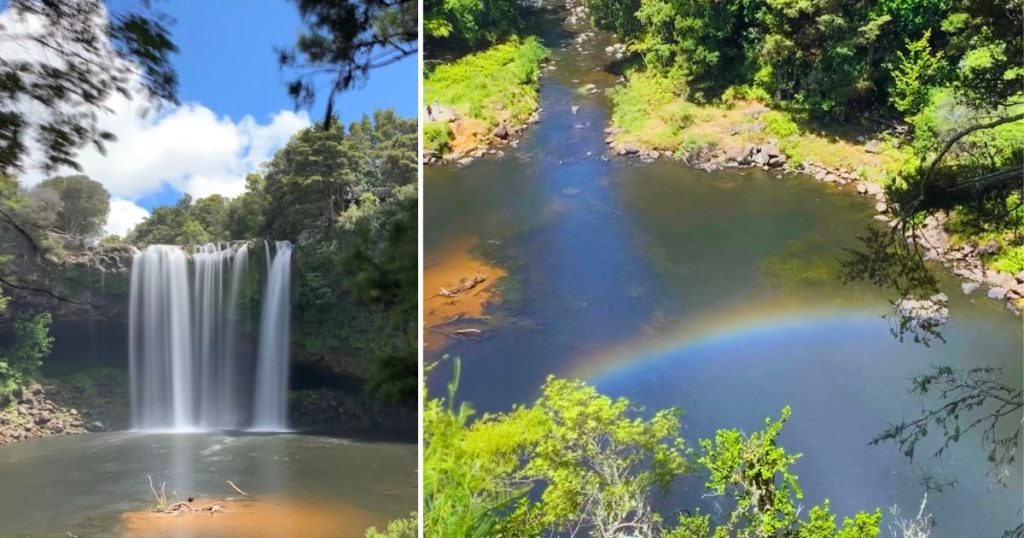
Walk through regenerating forest along the river. Side-streams and mossy banks as well as overhead shade make it an easy wander. You also pass the remains of the historic Kerikeri hydro-election station, which you can walk around and into. Finish at the rainbow Falls. (Note that you will need to either walk back or arrange to get back to your car in some way.)
Stay in Paihia at..
High End – Tarlton’s Lodge, or, Sanctuary Palms
Mid Range – Rekindle Treehouses, or, Allegra House
Budget – Bay of Islands Lodge, or, ASURE Admirals View Motel
Backpackers – Bay of Islands Lodge, or, Centabay Lodge, or Haka House Bay of Island
For a small apartment style hotel – Edgewater Palms Apartments
4. Signal Station Track Scenic Outlook
Time and distance: 30-60 mins, 1.3km return
AllTrails Map: Heritage Track to South Head Lookout Point Loop
Start at the Arai Te Uru Recreational Reserve carpark off SH12 just south of Omapere.
This has to be one of the best ‘least effort, maximum reward’ walks around! Follow the cliffs, through some manuka to the headland overlooking the entire Hokianga Harbour. You can also walk down to Martins Bay on the harbor from this track – only an extra 10-15 minutes walking. Hard to beat!
Stay nearby or at Opononi at..
High End – Waipoua Lodge
Mid range – Opononi Bliss
Budget – Wisteria Way
Small group or family – Waiotemarama Falls Lodge

5. Trounson Kauri Park Loop Track

Time and distance: 40 mins, 1.6km loop
AllTrails Map: Trounson Kauri Walk
Start at the campground or car park on Trounson Park Road which is off SH12 south of the Waipoua Kauri Forest.
An easy-peasy walk with a spectacular stand of towering kauri trees.
The forest is also home to the North Island brown kiwi so it’s a great idea to camp here and walk at night as well as during the day! That definitely makes this one of the best short walks in the North Island of New Zealand.
P.S. Visit the nearby Waipoua Kauri Forest to see the majestic Tāne Mahuta, New Zealand’s largest living kauri tree.
Stay nearby or at Opononi at..
Any of the places listed in walk 4 above.
6. Tutukaka Heads Track
Time and distance: 1 hour, 2km return
AllTrails Map: Tutukaka Lighthouse Track
Start at the end of Landowners Lane which is a private road, sign posted off Matapouri Road 400 m past the Oceans Resort Hotel.
(Please be respectful to the landowners of this private road so it remains accessible.)
This is a perfect walk for fun, views and swimming. The track runs along a headland up and down to the lighthouse on the headland and the ocean views you would expect!
Note that the lighthouse is on Kukutauwhao Island, which is only an island at high tide. Of course, you need to be careful to not get stuck there at high tide and take extra care before crossing if its rough weather. At low tide, follow the old lighthouse power-poles to where the track restarts on the island.
Stay in Whangarei at..
Higher End – Deloraine Stone Cottage
Mid range – Bk’s Pohutukawa Lodge
Budget – The Yurt Wai Rua, or, Highlander Farmstay – Cabins
Backpackers and budget – The Cell block (yes it was a jail)
7. Mount Manaia Track

4km return – 2 hours
Link: Mount Manaia Track
Drive out on the Whangarei Heads Road and you see this cool looking rocky hill on the way. Its all uphill but not hard and you walk through nikau palms, kauri and northern rata amongst other bush. The views over the Whangarei Heads and surrounding area from the top are fab-u-lous!!
Oh – and last time I walked this I saw a kiwi in broad daylight so keep your eyes open! you will see others but its most likely to be locals.
Stay in Whangarei at..
Any of the places listed in walk 6 above.
8. Waipu Caves Track
Time and distance: 30 mins ( for the caves) 1.5 hours (for the track), 4km return
AllTrails Map: Waipu Caves Track
Start the walk by the caves.
The caves are off State Highway One, on Waipu Caves Road, south of Whangārei and near Waipu.
Simply enjoy the trees by the carpark and walk over to explore the caves. Or explore the caves and then take the track walk through rocky landscapes, farmland and regenerating bush for some super cool views across the Whangārei Harbour and out to the Hen and Chicken Islands.
The caves are great – walk to the left up the stream until you get far enough to see the glow-worms. Again the free glow-worm show definitely puts this walk into the the 30 best short walks in the North Island of New Zealand.
Note – Check the weather before you go into the cave as they can get flash floods, and of course, don’t forget your torch/phone! Turn it off to see the glow-worms.
Stay in Whangarei at..
Any of the places listed in walk 6 above.

9. Mangawhai Cliffs Walkway
Time and distance: 2 hours, 9km return
AllTrails Map: Mangawhai Cliffs Walkway
This walk gives you great coastal views from Bream Head to the Tāwharanui Peninsula and on a clear day you can see as far as the Coromandel Peninsula and Great Barrier Island!
The track starts along the beach, climbs up a steep section to a lookout point then follows the clifftops to finally go down to a stony beach. Note that you can walk back along the beach in a loop but only at low tide.
Stay in Mangawhai at..
Holiday Home – Mangawhai Estuary View Haven
Mid range – Sailrock Studio or Dune View Accommodation
Budget – Redshed Studio Mangawhai
10. Takapu Refuge Walk / Muriwai Gannet Colony
Time and distance: 30 mins, approx. 1km return
AllTrails Map: Takapu Refuge Walk and Maori Bay Track Loop
Start at the carpark at Māori Bay at Muriwai Beach.
Take in views across the Tasman Sea all the way to a viewing platform overlooking the local gannet colony. Watching the birds and their antics from approximately Sept to May is an absolute treat.
There are two viewing platforms and it is worth walking to both. The wild views out to sea with the birds whirling through the sky around you is not to be missed.
Stay in Auckland at..
Higher end – the Park Hyatt Auckland, or, InterContinental Auckland By IHG
Mid range – Hotel DeBrett or Hotel Grand Chancellor or Horizon By SkyCity
Budget and Backpackers – for a lovely homestay try Kiwi Heritage Homestay. For backpackers the LyLo Auckland and JO&JOE Auckland are both top-rated!

11. Kitekite Falls Track
Time and distance: 1 hour, 2.75km return
AllTrails Map: Kitekite Falls Track
Start at 105 Glen Esk Road, Piha
The path is well paved with two river crossings, through beautiful forest and a fab 40-meter stepped waterfall at the end. Yes you can swim – it’s cool (literally)!
Its worth taking the (steep) walk on to the top of the waterfall too – you can have another swim there in one of the pools. A perfect walk close to Auckland CBD.
If you want a great tour which covers a few of these walks try this Private Piha Beach, Kitekite Falls Rainforest Adventure & Mt. Eden with Guide. It covers walks 9, 10, and Piha Beach and Mercer Bay Loop which is a good alternative to walk 8!
Stay in Auckland at..
Any of the places listed in walk 10 above.
12. Mt Eden Volcano / Maungawhau
Time and distance: 60 mins, 4.7km return
AllTrails Map: Maungawhau / Mt Eden Path
Start from Puhi Huia Road, Mt Eden, Auckland
Take a walk – right in the heart of Auckland this time. It’s definitely worth walking up at least one of the dormant volcanos the city sits on (with another option being One Tree Hill).
Looking from the peak down into the green crater reminds you of exactly what you are standing on, meanwhile the views over the city and harbor are hard to beat.
Stay in Auckland at..
Any of the places listed in walk 10 above.

13. Mautohe Cathedral Cove
Time and distance: 1.5hours, 2.5km return
AllTrails Map: Mautohe Cathedral Cove Track from Hahei Visitor Car Park
Start from the carpark which you have to get dropped off at, or a paid shuttle service to from the Hahei township.
Walk through farmland, pohutakawa trees, and stop off at pretty little beaches en-route to the iconic Cathedral Cove. Walk through the ‘cathedral’ cave to the white sandy beach and beautiful blue waters. It may only be a short walk but allow time to spend a day at the beach!
This walk is hugely popular for a reason and is an absolute must when talking about the best short walks in the North Island of New Zealand – although to be fair, its much better on a good sunny day!
Insiders local tip. Shhh, but, you can walk along Hahei beach to a track on the north end that takes you up to the carpark to start this walk. Skip the shuttle!
If you are in Whitiangi, you can cheat and take a cruise along the coast – including to Cathedral Cove!
Stay in nearby Hahei at..
Mid range – Hahei Island Views, or, The Church Accommodation
Budget or backpacker – nice private rooms and dorms at the Tatahi Cove Back Packer

14. Waikorire Track on Mauao / Mount Manganui / “The Mount”

Time and distance: 1.5 hours, 6.4km return
AllTrails Map: Mount Maunganui
CLOSED AFTER A LANDSLIDE – check for re-opening in 2027.
Start at the surf life-saving club at the end of Marine Parade, Mount Maunganui.
It’s the iconic thing to do in Mount Maunganui. Wind your way around ‘the mount’ until you reach the top and its 360 sea, bush, and city views. There are two walking options given in the AllTrails link above.
Great for an early morning hike to catch the sunrise and then grab a swim at the beach when you get back down.
Stay in Tauranga at..
A unique stay – at Jungle Den
Mid Range – Colonial Court Motor Inn, or, CitySide Hotel Tauranga
Budget and backpacker – Arty Apartments, or, Welcome Bay Heights
15. Karangahake Windows Walk
Time and distance: 1hour, 2.5km loop
AllTrails Map: Karangahake Windows Walk
Start at the Karangahake Reserve car park off SH2 between Waihi and Paeroa.
Walk over a swing-bridge to an old rail track which takes you to what once were gold-mining tunnels. Along the tunnels are ‘windows’ that give impressive views down into the river gorge below. The loop takes you across the river to the other side, where you follow the river back to the car park.
An interesting historic, as well as scenic, walk!
Stay in nearby Tauranga at..
Any of the places listed in walk 14 above.

16. Blue Spring Te Waihou Walkway
Time and distance: 40 mins, 1.5km return
AllTrails Map: Blue Spring Te Waihou Walkway
Start at the Leslie Road car park not far from Putaruru.
The water from this natural spring is so crystal clear and blue it’s some of the most beautiful water you will see in the country.
It has been naturally filtered for 100 years before it emerges from the spring. As a bonus, you might see trout swimming in the river too.
If you walk on a little further from the spring you will come to an old mill – it’s in a very pretty part of the longer track you can take to the spring.
The longer (7km to the springs – 9km to Leslie Road, 3 hour return) walk, weaves through farmland and regenerating bush from Whites Road.
Stay nearby or close by in Tauranga or Taupo at…
Local – Lakeview Lodge Karapiro, or, Above the River Karapiro Bed & Breakfast, or, Shargmor Stable
Tauranga – Any of the places listed in walk 14 above.
Taupo – Any of the places listed in walk 23 below.

17. Tologa Bay Wharf
Time and distance: 30 mins, 1.3km return
AllTrails Map: Tologa Bay Wharf
Start at Tologa Bay, East Cape.
How about a short and unusual walk in Tologa Bay on the East Cape of the North Island? The Tologa Bay Wharf is 660 meters long and is a favorite place for locals to fish. You are likely to see some sea life when walking out to the end when the sea is calm. Marvel at the surrounding cliffs and caves, and consider a sunrise or sunset walk – it can be magical.
Note that from here you can also head along the Cooks Cove walkway to the bay where Captain Cook stopped in 1769 to repair his ship and get provisions (2.5 hours, 5.8km return).
Stay in nearby Gisborne at..
Higher end – Matawhero Wines
Mid range – Whispering Sands Beachfront Motel
Budget – The Lookout, or, Village Apartments Gisborne
18. Ruakuri Bush Walk
Time and distance: 45 mins, 1km loop
AllTrails Map: Ruakuri Tunnels Walk
Start 4 km from Waitomo Village on Tumutumu Road – you will see signposts for the walk.
Right by Waitomo and, I think, pretty cool in its own right. This path follows the stream, through forest and rocky areas to a viewing platform in a tunnel with stalagmites and stalactites. Of course, at night, you can get a free show from the resident glow-worms (best near the bridge). Don’t forget your torch!
You can, of course, also go see the main glow-worm attractions while you are here – I guess that’s why you’d make the trip – right? Check out these options for either the adventurous or chill types:
- Guided Eco-Cave Tour
- Ruakuri Cave 1.5-Hour Guided Tour
- Waitomo Caves Labyrinth Black Water Rafting Experience
- Waitomo Caves Black Abyss Ultimate Caving Experience
Stay in Waitomo, Otorohanga, or Te Kuiti at…
Higher – Mid range– 1920s Character Home & Private Garden Retreat or The Rimu Hut – Off-grid Luxury riverside cabin
Budget – Aranui Farmstay or Waitomo TOP 10 Holiday Park
Backpackers – YHA Waitomo Juno Hall Backpackers
19. Te Auheke Track (Cascade Falls)

Time and distance: 40 mins, 1.5km return / loop
AllTrails Map: Te Auheke Track (Cascades Track)
Start at the Ōkataina Outdoor Education Center (it’s very obvious) just off Lake Ōkataina Road off the road between Whakatane and Rotorua. Go behind the Education Center not to the track beside the carpark. The sign is not obvious until you get close!
This has to be a real favorite of mine yet I’m hard pressed to say why. Te Auheke means ‘tumbling water’ and I guess that’s got something to do with it! It’s short and easy and just, well, beautiful.
The forest felt special to me, and the falls you come to are simply a heavenly little creation. Even though there is no spectacular view or glowworms etc, I simply had to include this one in the best short walks in the North Island of New Zealand.
You can either return the way you came or cross the little bridge by the Sign to the cascades. When you reach the Western Okataina Walkway – go right on the Rongomai Track back to the Outdoor Education Center.
The best thing is, that’s just during the day. Come back at night (spend the rest of the day at one of the lakes nearby), with your headtorch, and back to the waterfall. Thousands of glow worms!! Just fabulous.
Stay in Rotorua at..
High End luxury – On The Point – Lake Rotorua or Solitaire Lodge
Mid Range – Black Swan Lakeside Boutique Hotel, Quest Rotorua Central
Budget – Lake Ōkāreka Retreat
Backpackers – Rock Solid Backpackers Rotorua, or, Crashpalace Backpacker Rotorua
20. The (Cheats version of the) Tarawera Trail
Time and distance: 1.5 hours, approx. 4km
AllTrails Map: Tarawera Trail to Hot Water Beach (note that this shows the full track)
Start at Wairua Amenity area on the Tarawera Trail and walk to the Hot Water Beach campsite in Te Rata Bay.
To get there, get the water taxi from Kariri Point Reserve off Spencer Road near Rotorua to the Wairua Amenity area (hot pool). Then get the water taxi back out from Hot Water Beach.
BTW – I made that name up – there is no such trail as The Cheats Tarawera Trail. But, with the help of the water taxi ride or two, you can do this section of the beautiful Tarawera trail instead.
Arrange with the very easy-going water taxi service to drop you off at the hot pool at Wairua Amenity area and then pick you up later the same day, or the next day if you want to camp at Hot Water Beach.
The Wairua drop off point is at a picture-perfect natural hot water swimming pool in the bush a 1-minute walk from the lake. Soak in the absolutely consistent bath like water and run to and fro to the lake for a cool off. Frogs croaking, dragonflies buzzing, and nothing to do but relax – before you walk over to Hot Water beach. Not only is this one of the best of the best short walks in the North Island of New Zealand, its also part of one of the best day / overnight walks in the island.
Again, after the walk, you can soak in hot water. This time not so consistent as in the pool – but the lake water at the beach, on the top at least, is a good very warm bath-like temperature. Just be careful as the vents can be hot. Wear crocs in the water just in case, or go slowly. It’s a great campsite too.
Stay at the lake or in Rotorua at..
Any of the places mentioned in walk 19 above, or also consider Te Whare – Lake Tarawera tree-top Nest, or The Cabin.

21. Redwood Memorial Grove Track – Whakarewarewa
Time and distance: 30 mins, 2km return
AllTrails Map: Redwood Memorial Grove Track
Start at the visitor center and treetop walk on Titokorangi Drive – well signposted from Highway 30 /
Te Ngae Road in Rotorua.
I don’t normally like exotic trees out of their native place, let alone forests, but this one is definitely, and unusually, ok by me!
Walk through towering and magnificent 75m redwoods dedicated to the men of the NZ forest Service that died in the world wars.
Cross an old thermal pool with pretty, and also exotic plant life, and see the huge tree dedicated to Mary Sutherland, the first female Forestry Graduate in the world. She graduated from Bangor University, Wales in 1916 and was with the New Zealand Forestry Service from 1923 to 1933.
Also – don’t miss the treetop walk, especially at night! Wait until its really dark and let it spark the childhood magic side of you!
Stay in Rotorua at..
Any of the places listed in walk 19 above.

22. Kuirau Park and Rotorua Lakeside
Time and distance: It depends what you do but allow 2 hours for about 5-6km
AllTrails Maps: Kuirau Park Loop and Sulphur Point Loop Walk
This is not a formal walk but takes in the best sights of Rotorua – allow an hour or two!
Find Kuirau Park in the middle of Rotorua – there are a number of walkways through the gardens and park. See the steamy and bubbling crater lake, mud pools, hot springs, and take a free thermal foot bath. The park is easy to walk to from the city center – just off Pukuatua and Ranolf streets.
From the park, walk to Prince’s Gate and head over to the path beside the Polynesian Spa. Walk toward the Government Gardens and on to Sulphur Point. this takes you through an active thermal area with beautiful views of the lake. Follow the path, as you walk around the lake where you will see Mokoia Island.
If you want to make a loop walk back to Kuirau Park, keep walking to the Lakefront (lots of activities there) and head up ‘Pukeroa Hill’ to the hospital. From here take in the perfect views over the lake with St Michael’s Catholic Church, and Ohinemutu Maori Village below. You can then head back to Kuiau Park which you should see once you pass the hospital.
Stay in Rotorua at..
Any of the places listed in walk 19 above.
23. Huka Falls Loop or Lookout Walk

Time and distance: 30 mins, 0.8km
AllTrails Map: Huka Falls Loop
Start at the Huka Falls carpark off Wairakei Drive, just north of Taupo.
Don’t drive by this very short and very spectacular stroll! Watch as a big river gets squeezed into a small channel only 15 m wide – the force of the water is massive! Watch from the bridge but then take the path to the end of the channel to see the waterfall as it spews into the mighty Waikato River. Natures forces at their best!
You could also walk from Spa Park to the falls 3km one way and 1.5 hours. Best if you have two cars and can drop one at the other end before starting the walk.
Stay in Taupo at..
High End – Lake Taupo Lodge, or, The Flying Trout Boutique Lodge
Mid Range – Acacia Lake View Motel or Lakeview Escape – Modern Comfort in the Heart of Taupo
Budget – The Belfry
Backpackers – Finlay Jacks Backpackers, or, Adventure Taupo Hostel
24. Tokaanu Thermal Walk

Time and distance: 15 mins, 500m loop
AllTrails Map: Tokaanu Thermal Pools and Park Loop
Start at Mangaroa Street, Tokaanu – next to the Tokaanu Thermal Pools.
This is a very short free walk through a thermal area with steaming hot mineral pools and bubbling mud pools.
You may also see brown trout in the cold stream that flows alongside the thermal area – look down from the bridge near the entrance.
Next door are the Tokaanu Thermal Pools if you feel like a hot mineral soak.
Stay in the Tongariro National Park or at Turangi at..
High End – The Flying Trout Boutique Lodge or River Birches
Mid Range – Braxmere Lodge or The Quarters
Budget – Creel Lodge
Backpackers – The Crossing Lodge & Backpackers, or, Tongariro River Retreat
25. Lake Rotopounamu

5km loop – 2 hours
Link: Lake Rotopounamu
Walk through beautiful native bush to a lake with birds all around – literally. The frogs can be pretty raucous too at each end of the lake in the summer.
My recommendation is to take a picnic and swim gear and make a bit more of a day of it! When the sun is shining the lake is a lovely green – either way its shallow and perfect for swimming.
For some reason just about everyone seems to drive on by so you shouldn’t see too many people on this off the beaten path gem.
Stay in the Tongariro National Park or at Turangi at..
Any of the places listed in walk 24 above.
26. Meads Wall
Time and distance: 30 mins, 2.2km return
AllTrails Map: Meads Wall
Start at the carpark at the end of the Bruce Road to the Whakapapa Ski field in Tongariro National Park.
Walk toward the gondola where you should see a sign saying ‘Meads Wall walk.’
It’s a short, rocky, and fun trail with amazing views over very steep cliffs. It’s also a well-known rock-climbing and filming location – yes, including Lord of the Rings!
If you want more adventure, you could try the nearby Skyline walk. (Take the gondola to the top and walk to the Skyline Ridge in summer only. 1.5-2.5 hours.)
A fun alternative is this Tongariro Discovery walk which goes to Taranaki Falls, gives you amazing views of Mount Ruapehu and Mount Ngauruhoe, and then either walk to the Tama Lakes or Lake Rotopounamu, depending on group fitness levels.
Stay in the Tongariro National Park or at Turangi at..
Any of the places listed in walk 24 above.
27. Tawhai falls / Gollum’s Pool
Time and distance: 20 mins, 600m return
AllTrails Map: Tawhai falls / Gollum’s Pool
Start at the carpark on the SH48 road to Whakapapa Village, 4 km from the Tongariro National Park Visitor Centre.
Another Lord of the Rings movie location, and a very short and pretty walk through mountain toatoa and beech forest with wonderful views out to the volcanoes to the falls.
There are a number of other short to 2-3 hour walks in the area. If you have time check out the Silica Rapids Walk (2.5 hours) or the Taranaki Falls Walk (2 hours). Both are excellent walks with varied terrain and flora
Stay in the Tongariro National Park or at Turangi at..
Any of the places listed in walk 24 above.

28. Paritutu Rock Walk
Time and distance: 30 mins, 200m return
AllTrails Map: Paritutu Rock Walk
Start at the carpark off Centennial Drive in New Plymouth.
Walk up the iconic New Plymouth 156m tall ‘rock.’ Don’t be fooled by the distance. Its straight up and you don’t want to not like heights or a bit of rock scrambling (with a chain to help you) to get yourself up to the top.
The reward?
A 360 view over New Plymouth, the beaches and Mt Taranaki in all its glory (as long as its fine)!
Stay in New Plymouth at..
Higher End – King and Queen Hotel Suites or Nice Hotel
Mid range – Beachside studio or Beach Street Motel Apartments
Budget and Backpackers – Ariki Backpackers, or, Ducks and Drakes
29. Wilkies Pools Loop
Time and distance: 80 mins, 1.9km return
AllTrails Map: Wilkies Pools and Dawsons Falls Loop
Start at the Dawson Falls Visitor Centre in the Egmont National Park, about 24km from Stratford.
It’s beautiful. You wander 20 mins on an easy path through a ‘goblin forest’ full of moss covered gnarly old kamahi trees to some gorgeous lava pools. Yes you can swim in them – if you don’t mind cold water!
Either return the same way or continue on the loop. If you take the loop, you do have to rock hop across the river. This will be easy in summer but not so easy in winter. I think the goblin forest alone puts this walk in the ranks of the best short walks in the North Island of New Zealand, but the pools and forest and views you get make it super special.
Note: The path can be very icy in winter – and I mean really icy, but that’s just winter!
If you have the time, nearby is the Kapauni Loop track, steep in parts, through more lovely goblin forest and viewpoints over the Dawson falls.
Stay in New Plymouth at..
Any of the hotels mentioned in 28 above.
30. Durie Hill Elevator and Tower Walk

Allow at least 30 mins, 500m return
Time and distance: Allow at least 30 mins, 500m return
AllTrails Map: Durie Hill Tower
Start at 42 Anzac Parade, Durie Hill, Whanganui.
An unusual one for me – it’s right in the city of Whanganui! This is something different, and fun to boot, so why not?
Walk through the long (213m) tunnel to New Zealand’s only public transport elevator! You will be greeted by an elevator host who will take you up 66 meters in the original elevator ($2.00) to the top where you can walk over to the nearby tower.
The 33.5-metres high (104 feet) Durie Hill War Memorial Tower was built a few years later, and once you climb the circular 193 steps you will be rewarded with magnificent views across the city and river below – on a good day you may even see the mountains further north. The rock the tower is made from comes from a local quarry and is estimated to be 2 million years old.
It may not be forest and things au naturel, but I think the mix of unusual and views are what makes it one of the best short walks in the North Island of New Zealand.
Stay in Whanganui at..
For something different try the Takahuri Glamping Domes
Mid range – Private Guest Wing – Durie Vale Lodge or, ASURE Cooks Gardens Motor Lodg
Budget and backpacker – Allie’s Hill Top Haven Bed & Breakfast
31. Castlepoint Lighthouse Walk
Time and distance: 30 mins, 1.3km return to the lighthouse / 3km – 1 hour 30 return for Castle Rock
AllTrails Map: Castlepoint Lighthouse Walk and Deliverance Cove Track Loop
Start at the end of the Castlepoint Rd approximately 1 hour from Masterton, Wairarapa.
Follow the path up to the lighthouse base, then carry on to the lookouts beyond where you have sweeping views across the Wairarapa Coast. Continue on the loop in the path back to the lighthouse, and check out the fossils in the rocky headland on the way. Watch for sea birds and possibly dolphins and fur seals out at sea.
While you are there look for one of the world’s rarest daisies – the Castlepoint daisy! It’s a bushy, low growing, evergreen flowering shrub with oval-shaped leaves which are green above and white below and it has yellow flowers in summer. It may be short but its spectacular. Also, listen to the blowholes on the way up which work quite well at high tide.
Second, walk from the carpark by the church along the hill above “the lagoon” to Deliverance Cove viewpoint below Castle Rock. Enjoy the view from the conveniently placed seat. You can walk down and back to your car via the beach. Watch out when you reach the beach as there are often seals there. Keep your distance!
If you want to climb up to Castle Rock for the stunning view back to the lighthouse you need to be very good with heights – absolutely no vertigo. And there are no safety barriers – do not take children unless you know they will stick with you and do exactly what you tell them! It is considered dangerous so make up your own mind – but also do not go up if it is very windy!
Stay in Masterton at..
Stay in Masterton an hour away at:
High End – 5 o’clock Somewhere
Mid range – Le Grá Vineyard and Winery
Budget – Gateway Motor Inn

32. Donnelly Flat Loop Walk
Time and distance: 1 hour, 2.5km return
AllTrails Map: Donnelly Flat Loop Walk
Start at the end of the Mount Holdsworth Road, just south of Masterton.
A flat short and easy walk, through superb podocarp forest, complete with picnic areas and a great swimming hole in the Atiwhakatu Stream at the start / end of the track. It is perfect on a hot day, although the water is a bit on the cold side.
If you have more time try the Rocky Lookout Walk 1.9km (uphill) that takes 1- 1.5 hours to walk each way.
You could also visit the not-too-far-away Waiohine Gorge to try one of New Zealand’s tallest and longest swing-bridges.
Stay in Masterton at..
Any of the hotels in walk 31 above.
33. Matiu / Somes Island Loop Track
Time and distance: 40 mins, 2.1km loop
AllTrails Map: Matiu / Somes Island Loop Trail
Get the ferry from the Meridian Building (Waterside), 55 Lady Elizabeth Lane, Queens Wharf, Wellington.
A really interesting island with wildlife, history, bush and 360 views around Wellington and its harbor.
The best part is that, since pests were eradicated, the island has become a successful sanctuary for native plants and animals including tuatara, kakariki, North Island robin, little blue penguins and weta.
Ask the rangers where you might see tuatara – or look in sunny spots where they are often seen sunbathing. No guarantee but….for the tuataras alone it is definitely one of the best short walks in the North Island of New Zealand
Stay in Wellington at..
Higher End – Ohtel Wellington, the Boulcott Suites, or for luxury – The Residence Suite at Bolton Hotel
Mid Range – The Intrepid Hotel, or Quest 256 Lambton, or Sojourn Apartment Hotel
Budget – Gilmer Apartment Hotel, or, Adina Citylife Wellington
Backpackers – Worldwide Backpackers, or, The Marion

34. Mount Victoria Loop – Wellington
Time and distance: 1.5hours, 5.0km loop
AllTrails Map: Mount Victoria Loop
There are lots of different walkways to the summit of Mount Victoria in Wellington and all are fun. At the top you get fabulous 360 views of the city and harbor, as well as seeing some interesting monuments. Go and see for your self rather than me spoil it for you!!
Stay in Wellington at..
Any of the hotels listed in walk 33 above.

35. Eastern Walkway – Wellington

Time and distance: 1.5hours, 5.7km loop
AllTrails Map: Eastern Walkway
Start either at the Pass of Branda between Seatoun and Breaker Bay at the top of Inglis Street, or at the carpark at Tarakena Bay on Great Harbour Way.
If you start at Tarakena Bay, first walk up to the impressive Ataturk memorial which looks out over Cook Strait to the South Island. Take in the superb views.
The memorial was the New Zealand response to the commemorative site at Anzac Cove which the Turkish government renamed from Ari Burnu in honor of the Australian and New Zealand men that fell there (including my great-uncle) during WWI.
Ataturk’s famous speech is inscribed at the memorial – worth reading as this is something very strongly ingrained in the national psyche.
Continue on along the tops to Seatoun.
You can do the walk in either direction – it just easier if you have 2 cars or are happy to do a round loop using the road to return. Otherwise there is an occasional bus (30X) which you can use.
Stay in Wellington at..
Any of the hotels listed in walk 33 above.
Things to pack when hiking in New Zealand
Apart from your backpack and food, these are the things I never go hiking without:
- Collapsible hiking poles
- Blister pads – an absolute lifesaver!
- A lightweight water bottle and filter – I personally use the Katadyn BeFree
- Merino socks
- An emergency survival blanket
- A headtorch
- A lightweight first aid kit and whistle
- A PLB (personal locator beacon) – this means search and rescue just becomes rescue and saves hours or days – especially essential if you hike alone!
- My downloaded AllTrails map on my phone
- A lightweight powerbank or solar charger for my phone
- Waterproof pack liner
Plus – your basic clothing:
- Hiking boots with good ankle support and grip
- Sun hat and / or warm beanie
- Sunglasses
- Base layer: top and leggings in polypropylene or wool, quick dry shorts or pants
- Mid layer: long sleeved top in wool or polar fleece
- Gloves in polypropylene/wool
- Socks in polypropylene or wool
- Wind and water-proof jacket with hood
- Waterproof over-trousers – optional but I always take them!
Frequently asked questions about walking and hiking in New Zealand
Q: What is “tramping” in New Zealand?
A: Tramping is the kiwi (NZ) word for hiking. Its fine to talk about hiking or bushwalking – they are all interchangeable.
Q: What is the best time of year to hike in New Zealand?
A: The warmer and dryer months are between November and April but the peak season is from December to the end of March. They also have longer daylight hours, and trails that are closed in the winter tend to be open by November.
Q: Are there dangerous animals or snakes in New Zealand?
A: No. New Zealand has no snakes, bears, or large dangerous land predators. Your biggest worry is meeting up with masses of sandflies near the coast, and maybe wasps during late summer.
Q: Is it safe to hike alone in New Zealand?
A: Yes, solo hiking is common and generally safe. However, you should know what you are doing – overseas travellers often underestimate the tracks and often rugged conditions in New Zealand. And because weather conditions can change dramatically, you should always check the forecasts, pack thermal layers as well as high quality water and wind proof gear, and leave your trip intentions with a friend or relative. I always take a PLB (personal locator beacon) as well – that saves the search if you need rescuing!
Q: Can I drink water directly from streams and rivers?
A: You should still filter, boil, or chemically treat backcountry water to avoid illnesses like giardia. Always carry water – and I always take a water filter with me – just in case. I use the Katadyn BeFree.
Q: Are DOC track times accurate?
A: Take the DOC estimated trail times with a grain of salt. The walking times are based on an average hiker’s pace but you can be slower or faster than that. Its a rough guide.
Q: What is an emergency Personal Locator Beacon (PLB), and do I need one?
A: A PLB is a lightweight safety device that emits a distress signal via satellite. If you get lost or are injured you can set it off and your position will be received by the appropriate services. I highly recommended you carry one whenever you hike – especially for remote or multi-day backcountry hikes – but I still carry mine for short walks unless they are heavily trafficked!
Summary
That’s thirty short walks for you – definitely 30 of the best short hikes in the North Island of New Zealand. Comment below if you think there is one I should have included, and do let me know what you thought of these ones.
Happy hiking!
Related Posts
The 12 best day walks in the North Island New Zealand (off the beaten path)
12 great multi-day hikes in the North Island New Zealand (off the beaten path)
10 beautiful walks in the Auckland area not to miss
Where to soak in the 11 best natural hot pools in the North Island of New Zealand!